[author: John Peiserich]
Introduction
“Geographic Information System” (GIS) describes any computer system that incorporates data related to location. GIS can present several different data points in a single map, which allows users to view and analyze trends and relationships present in the information. The benefits and applications of GIS touch practically every industry and are used today in everything from wildlife conservation to dating applications. In the United States, a key component of GIS technology is the publicly available U.S. Geological Survey’s National Map, which includes eight primary layers of data that can be overlaid on a continuous map of the US.
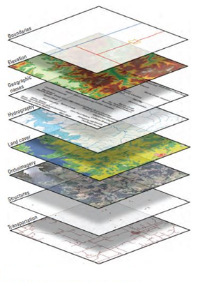
Figure 1 - Eight base layers of The National Map.
There are hundreds of GIS software services on the market. These products can incorporate industry-specific data as well as proprietary information management systems. The software offerings give ready access to GIS, and we see environmental, health, and safety (EH&S) related uses as excellent opportunities to do so.
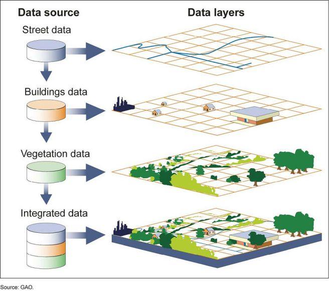
Figure 2 – Data sources and layers.
Uses for GIS
While GIS has been around for decades, industries are still discovering more ways to use GIS to improve efficiency and make datapoints more valuable. For example, based on the software being utilized, users can link reports, forms, and even photographs to a particular location. When personnel can access and upload GIS data from the field via a mobile device, users have real-time access to crucial data across their organization. This type of data management can prove useful for conducting inspections, providing incident reports, or issuing work orders. Tying this information to a location can improve communication, speed up response times, and reduce costs.
Additionally, advanced software can analyze data and automatically flag trends or risks associated with location data. For example, a construction company might use historical weather data as part of its scheduling process or to estimate project contingencies more accurately. On another note, a cluster of incident reports may alert a pipeline operator to a potential leak.
Environmental Risk Assessment and Compliance
GIS has consistently proven itself to be useful for environmental risk assessment and compliance. Because compliance often requires monitoring of extensive geographic areas, GIS is a logical choice for data management. For example, in 2007, the Allegheny County Sanitary Authority entered an Environmental Protection Agency (EPA) consent decree after the EPA found that the Authority’s sewer system was inadequate and wrongfully allowed 83 municipalities to discharge sewage into rivers. With the full compliance effort expected to take multiple decades and billions of dollars, the interested parties faced a unique challenge of designing and implementing a compliance plan for the many miles of infrastructure involved. As such, the consent decree required that the Authority utilize GIS technology to map data such as the configuration of the sewer system, rainfall, water quality test results, and the location of known outfalls and existing water bodies.
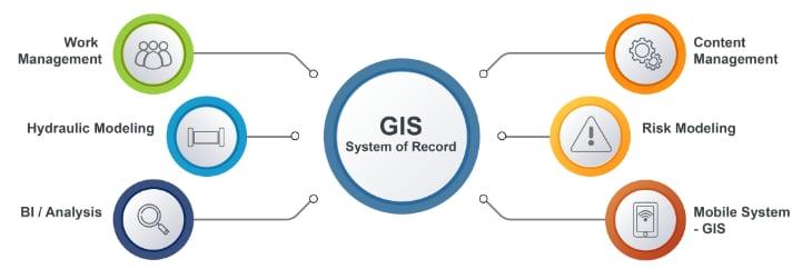
Figure 3 - Example of how a GIS system can be used for compliance.
Utilities
Additionally, companies involved in pipelines and electric transmission and distribution use GIS to plan construction routes across different terrains and population centers, as well as for maintenance of existing infrastructure. Location data becomes crucial to these industries during service outages and safety incidents. Having a centralized data platform also allows operators to share reports with regulators and consumers in real time.
Environmental Justice
While regulators have used GIS technology for years, the EPA recently developed EJScreen, a new publicly available tool that allows users to combine environmental and demographic data.This tool was developed as part of the federal government and EPA’s goal of improving environmental justice, which it defines as “the fair treatment and meaningful involvement of all people regardless of race, color, national origin, or income, with respect to the development, implementation, and enforcement of environmental laws, regulations, and policies.” Environmental justice seeks equal protection for all people from environmental and health hazards, and equal access to the decision-making process regarding environmental impacts to communities. The EJScreen tool furthers these goals by allowing stakeholders and community members to review data regarding environmental hazards and the communities that they impact. Because the EPA considers environmental justice factors in permitting and enforcement decisions, industry leaders can also utilize the tool to develop effective strategies to ensure compliance and reduce environmental impacts.
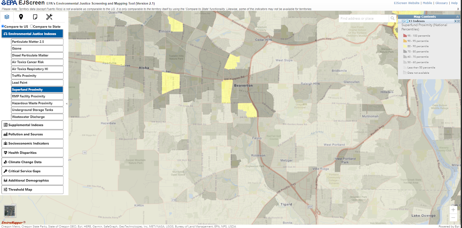
Figure 4 - EPA's Environmental Justice Screening and Mapping Tool (Version 2.1).
Regulated entities can also utilize GIS to monitor environmental and safety compliance at a facility- or site-wide level. For example, a site can plot groundwater monitoring wells into a GIS system to tell samplers which wells to test and when. Advanced GIS software can also store test result data to show constituent trends over time and highlight patterns such as plume movement or violations of maximum concentration levels.
Chemical Inventory Reporting, OSHA, and the EPA
Hazard Communication Standard (HCS) (29 CFR 1910.1200). In the preamble to that final rule, EPA stated that facilities should use the new physical and health hazards on their emergency and hazardous chemical inventory form (also known as the “Tier II reporting form”) for chemicals present at their facility. As a result, certain entities are required to report the amounts and locations of hazardous chemicals on an annual basis. This data is used by emergency officials to minimize the risk of explosions or releases during emergencies such as a fire. A regulated facility can track the location of regulated chemicals within their facility to reduce the cost of and aid in compliance with their annual reporting to local emergency officials. In turn, state and local emergency officials can map the facilities in their region that contain Tier II chemicals.
Relatedly, both the Occupation Safety and Health Administration (OSHA) and the EPA monitor facilities that use hazardous chemicals. The Clean Air Act Amendments of 1990 directed both entities to develop regulatory programs to reduce the risk of accidents involving hazardous chemicals. While OSHA focuses on on-site employee safety in its Process Safety Management Standard (PSM), the EPA’s Risk Management Program (RMP) Rule considers the risk of chemical accidents that could affect public health and the environment. While OSHA PSM emergency procedures concern personnel at industrial sites, EPA RMP incident procedures regulate chemical releases into the surrounding environment. For example, a remote site with no employees may be subject to EPA’s RMP program but exempt from OSHA’s PSM program.
Because there is so much overlap between the two regulatory schemes, the same facilities tend to be subject to both, and can often combine their compliance programs. Both regulations require a regulated facility to evaluate and document its entire chemical process, with the goal of mitigating or preventing failures in the process or equipment. Components of the required process safety management program include: an exhaustive inventory of regulated chemicals; descriptions or diagrams of the chemical processes and how chemicals move throughout the facility; equipment specifications; and a written inspection schedule and procedure based on equipment manufacturer recommendations. Owners and operators then use this data to prepare Process Hazard Analyses and emergency preparedness procedures in the event of an accident or chemical release.
GIS can be a useful tool for regulated facilities to comply with both OSHA’s PSM and EPA’s RMP. An owner or operator can map the facility’s chemical processes using GIS technology and even tie it into an emissions monitoring system. On the same platform, the facility can keep inventory of its regulated chemicals and maintain an inspection log for its equipment. This location-based data is helpful in tracking and minimizing employees’ contact with hazardous chemicals, and it can provide crucial information to first responders about what chemicals may be involved in a facility incident.
Conclusion
GIS technology is unique in that it can be useful for analyzing almost any process and is most useful when analyzing multiple processes together. Users across industries continue to find ways to integrate more data into these systems. With the world more connected than ever, the possibilities are immense. By tying environmental compliance efforts into a GIS program, users can improve compliance and reduce costs which are key drivers for industry today.
1USGS National Geospacial Program, The National Map, available at https://www.usgs.gov/programs/national-geospatial-program/national-map.
2 (Credit: Sexton, Pamela Ann. Public domain.); USGS, What is a geographic information system (GIS)?, available at https://www.usgs.gov/faqs/what-geographic-information-system-gis.
3NATIONAL GEOGRAPHIC, GIS (Geographic Information System), available at https://education.nationalgeographic.org/resource/geographic-information-system-gis.
4U.S. et al. v. Allegheny County Sanitary Authority, Civ. No. 2:07-cv-00737, Modified Consent Decree (May 14, 2020).
5https://www.udcus.com/solutions/pipeline-safety-management is an excellent example of how a GIS system can be used for compliance.
6National Pipeline Mapping System, https://www.npms.phmsa.dot.gov/About.aspx.
7EPA, What is EJScreen? (2022), available at https://www.epa.gov/ejscreen/what-ejscreen.
8EPA, Environmental Justice (2022), available at https://www.epa.gov/environmentaljustice.
9 EPA, EPA EJScreen (Version 2.1), available at https://ejscreen.epa.gov/mapper/.
1040 CFR Part 370.
1140 CFR Section 1910.119.
1240 CFR Part 68.
13EPA, Why are industries exempt under OSHA's PSM subject to RMP? (2022), available at https://www.epa.gov/rmp/why-are-industries-exempt-under-oshas-psm-subject-rmp.
14EPA, Does compliance under OSHA's PSM demonstrate compliance with the risk management program? (2022), available at https://www.epa.gov/rmp/does-compliance-under-oshas-psm-demonstrate-compliance-risk-management-program.
15OSHA, Process Safety Management Guidelines for Compliance (1994) at p. 1.
16EPA, General RMP Guidance-Chapter 7: Prevention Program (Program 3) (2004), available at https://www.epa.gov/rmp/general-rmp-guidance-chapter-7-prevention-program-program-3.
17See H. Atay and G. Toz, GIS as a Planning Tool for Health and Safety Management in Linear Construction Projects, ITU Civil Engineering Faculty (2010).
